[
Date Prev][
Date Next][
Thread Prev][
Thread Next][
Date Index][
Thread Index]
[
List Home]
|
[udig-devel] Some plotting issues and questions
|
Hi there,
Further to my previous email I am now trying to plot data using only WFS layers and a few issues / feature requests / bugs have come to light, hopefully the images attached will help illustrate and someone can point me in the right direction...
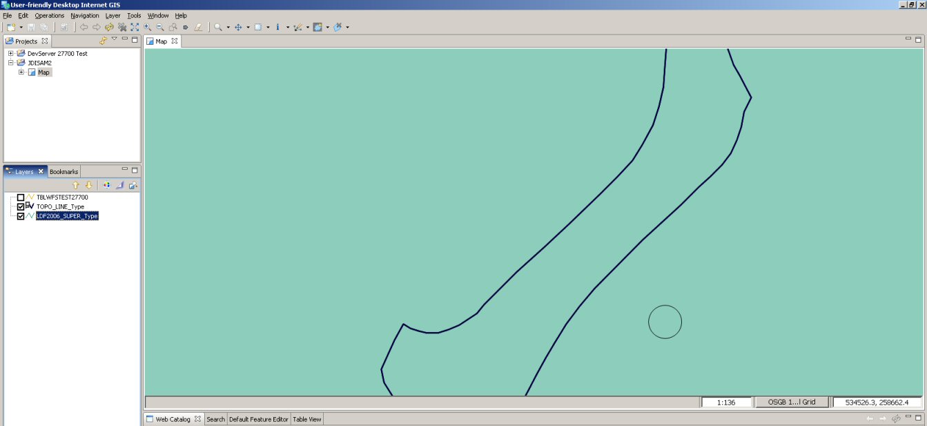
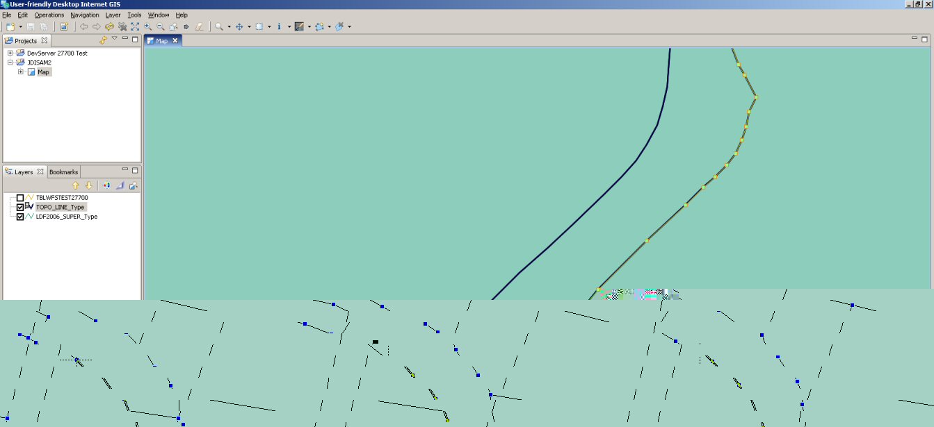
Snapping to points on any layerthis is great but is it possible to show all the nodes on the map so I can see what I'm snapping to before I click the mouse button? Image 1 (attached) shows a curved line in my base data that I want to snap to. (The circle is the cursor, no idea why the crosshair didn't get captured in the screen dump?!?!) Image 2 shows the same line highlighted for editing so that I can see where the nodes are. I would like to see this without having to select it for editing, is this possible?
Would it also be possible to show which node will be snapped before the mouse button is clicked?
Snapping to points on a different layerIs it possible to snap to points on just one other layer,
i.e. the base layer? In my case I have 1 or 2 base layers (which will have the same nodes so snapping to either is fine) and a bunch of data layers. I only want to snap to the base layers and I only ever want to edit the data layers.
Snapping to a lineIn MapInfo Pro you can not only snap to nodes in the same way you can in uDig, you can also snap to groups of nodes that are close together, like in the example of my curved line. If you hold the shift key whilst plotting you can join two points at either end of a curved line and MapInfo will add all the intermediate points. It will even show the line it is going to construct before you click to confirm. That's really cool and very useful when you have curved lines with lots of nodes, a regular feature in UK OS mapping!
See image mi1.jpg to see the line we're poised to snap to and mi2.jpg for MapInfo's reaction to us moving the mouse to the last node in the line while holding the shift key. Importantly it shows the line before the mouse button is clicked so we can be sure it's doing the right thing.
Problem rendering base layer once new feature added to data layer?3.jpg shows the result in uDig after I plotted a new polygon in my data layer (LDF2006_super), as you can see some of the base layer has been lost and uDig reports an error, at the bottom of this email is the log entry which appears to relate to it.
thanks in advance,
Tom
!ENTRY net.refractions.udig.project 2 0 2007-07-18 09:55:54.484
!MESSAGE Problem rendering: Exception rendering layer DefaultMapLayer[ Test, VISIBLE, style=StyleImpl<NO_PARENT>[ name=Default Styler], data=
"" query=Query: [Request All Features]
feature type: null
filter: NOT [ TOPO_LINE.nfm-64ed4e5f_113d846c1db_7b38 ]
[properties: ALL ]]
!STACK 0
net.refractions.udig.project.render.RenderException: Problem rendering: Exception rendering layer DefaultMapLayer[ Test, VISIBLE, style=StyleImpl<NO_PARENT>[ name=Default Styler], data=""
, query=Query: [Request All Features]
feature type: null
filter: NOT [ TOPO_LINE.nfm-64ed4e5f_113d846c1db_7b38 ]
[properties: ALL ]]
at net.refractions.udig.render.internal.feature.basic.BasicFeatureRenderer.render
(BasicFeatureRenderer.java:313)
at net.refractions.udig.render.internal.feature.basic.BasicFeatureRenderer.render(BasicFeatureRenderer.java:186)
at net.refractions.udig.project.internal.render.impl.RenderExecutorImpl$RenderJob.startRendering
(RenderExecutorImpl.java:303)
at net.refractions.udig.project.internal.render.impl.RenderExecutorImpl$RenderJob.run(RenderExecutorImpl.java:358)
at org.eclipse.core.internal.jobs.Worker.run(Worker.java:58)
Caused by: java.lang.Exception: Exception rendering layer DefaultMapLayer[ Test, VISIBLE, style=StyleImpl<NO_PARENT>[ name=Default Styler], data="" query=Query: [Request All Features]
feature type: null
filter: NOT [ TOPO_LINE.nfm-64ed4e5f_113d846c1db_7b38 ]
[properties: ALL ]]
at org.geotools.renderer.lite.StreamingRenderer.paint(StreamingRenderer.java:521)
at org.geotools.renderer.lite.StreamingRenderer.paint
(StreamingRenderer.java:429)
at net.refractions.udig.render.internal.feature.basic.BasicFeatureRenderer.render(BasicFeatureRenderer.java:296)
... 4 more
Caused by: java.io.IOException: org.geotools.ows.ServiceException
: null error:Translator error
at org.geotools.xml.gml.FCBuffer.hasNext(FCBuffer.java:324)
at org.geotools.data.wfs.WFSFeatureReader.loadElement(WFSFeatureReader.java:206)
at org.geotools.data.wfs.WFSFeatureReader.hasNext
(WFSFeatureReader.java:167)
at org.geotools.data.ReTypeFeatureReader.hasNext(ReTypeFeatureReader.java:149)
at org.geotools.data.wfs.NonStrictWFSStrategy.createFeatureReaderGET(NonStrictWFSStrategy.java:141)
at org.geotools.data.wfs.NonStrictWFSStrategy.createFeatureReader(NonStrictWFSStrategy.java:103)
at org.geotools.data.wfs.StrictWFSStrategy.access$001(StrictWFSStrategy.java:44)
at org.geotools.data.wfs.StrictWFSStrategy$StrictFeatureReader.init
(StrictWFSStrategy.java:112)
at org.geotools.data.wfs.StrictWFSStrategy$StrictFeatureReader.<init>(StrictWFSStrategy.java:88)
at org.geotools.data.wfs.StrictWFSStrategy.createFeatureReader(StrictWFSStrategy.java
:68)
at org.geotools.data.wfs.NonStrictWFSStrategy.getFeatureReader(NonStrictWFSStrategy.java:75)
at org.geotools.data.wfs.WFSDataStore.getFeatureReader(WFSDataStore.java:833)
at org.geotools.data.DefaultFeatureResults.reader
(DefaultFeatureResults.java:147)
at org.geotools.renderer.lite.StreamingRenderer.getReader(StreamingRenderer.java:1290)
at org.geotools.renderer.lite.StreamingRenderer.processStylers(StreamingRenderer.java:1388)
at org.geotools.renderer.lite.StreamingRenderer.paint(StreamingRenderer.java:518)
... 6 more
Caused by: org.geotools.ows.ServiceException: null error:Translator error
at org.geotools.xml.XMLSAXHandler.endElement
(XMLSAXHandler.java:256)
at org.apache.xerces.parsers.AbstractSAXParser.endElement(Unknown Source)
at org.apache.xerces.impl.XMLNSDocumentScannerImpl.scanEndElement(Unknown Source)
at org.apache.xerces.impl.XMLDocumentFragmentScannerImpl$FragmentContentDispatcher.dispatch
(Unknown Source)
at org.apache.xerces.impl.XMLDocumentFragmentScannerImpl.scanDocument(Unknown Source)
at org.apache.xerces.parsers.XML11Configuration.parse(Unknown Source)
at org.apache.xerces.parsers.DTDConfiguration.parse
(Unknown Source)
at org.apache.xerces.parsers.XMLParser.parse(Unknown Source)
at org.apache.xerces.parsers.AbstractSAXParser.parse(Unknown Source)
at javax.xml.parsers.SAXParser.parse(Unknown Source)
at javax.xml.parsers.SAXParser.parse(Unknown Source)
at org.geotools.xml.DocumentFactory.getInstance(DocumentFactory.java:140)
at org.geotools.data.wfs.WFSFeatureReader.run(WFSFeatureReader.java:126)
Caused by: org.geotools.ows.ServiceException: null error:Translator error
at org.geotools.xml.filter.FilterComplexTypes$ServiceExceptionType.getValue(FilterComplexTypes.java:1669)
at org.geotools.xml.handlers.ComplexElementHandler.endElement
(ComplexElementHandler.java:156)
at org.geotools.xml.XMLSAXHandler.endElement(XMLSAXHandler.java:248)
... 12 more
Attachment:
1.jpg
Description: JPEG image
Attachment:
2.jpg
Description: JPEG image