Spatial Data and Precision Agriculture
Precision Agriculture is a methodology of farm management that relies on data, and data analysis to support the farmer’s decision-making process to decrease inputs.
The origin of Precision Agriculture begins with researchers collecting soil samples, and using spatial statistics methods to determine the different soil types in a field. From this analysis, the researchers developed soil maps. Farms were early adopters of both GPS and Geographic Information Systems (GIS) technologies. As civilian GPS became more accurate, farms started to utilize this technology to increase the accuracy of operational spatial data. Collecting spatial data from equipment and sensors that allowed farms to pinpoint the high yield areas. Also, using GPS data to determine where to increase or decrease pesticides, fertilizers use and irrigation.
Software as a Farm Input
The business case for Precision Agriculture methods is the reduction of farm inputs. Farm inputs range from equipment, seeds, pesticides to energy. In turn a reduction in farm inputs reduces the overall cost to produce a harvest.
Modern farm inputs include an Internet of Things (IoT) ecosystem - networks of advanced sensors, auto guided driving tractors (harvesting both crops and data), servers and drones. Furthermore, data purchased is also a farm input. The data purchased by the farm assist in the planning and execution of the harvest, such as weather feeds, and satellite imagery.Harvesting, Both Crops and Data
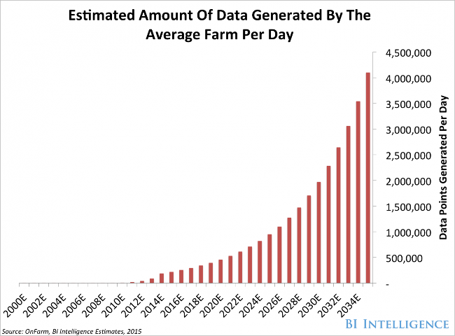
During planting and harvest, these farm inputs yield more data for the farm to analyze. Location of tractors and their status, drone flights to find areas of crops under duress and the yields of individual fields. Smaller farms may only generate a few hundred rows of data a day, while a large farm could generate billions.
According to Business Insider, the amount of data generated by the farm will dramatically increase over the next 20 years.As the amount of data the farm generates increase, data management and analysis becomes more difficult and costly.
Open Source Software, and Farming
Free and Open Source Software for Geospatial (FOSS4G) technology can play a role in reducing the cost of software inputs, and allow farms to analyze and visualize their data.
Two LocationTech software projects, hosted at the Eclipse Foundation, can assist farms with the analysis of large amounts of spatial data: LocationTech GeoMesa and LocationTech GeoTrellis.
GeoMesa
GeoMesa brings spatiotemporal analytics and visualizations to Accumulo, a scalable data storage and retrieval system. Farms that leverage GeoMesa will be able to perform large scale analysis on their vector data. Vector data is normally collected by sensors and tractors - general operational data. Vector data can also include weather reports, and any data that has been converted from raster to vector.
By giving the farm the ability to process these massive operational data sets, insights into the impact of the day to day operations on the harvest become clearer. These analyses will give the farm a better understanding of how to manage operations and apply these lessons learned to the next harvest season.
To learn more about GeoMesa, read this article.
GeoTrellis
GeoTrellis can batch process massive amounts of raster data. With daily satellite updates, and on the fly drone collection, the amount of raster data collected by farms has never been greater.
By using GeoTrellis a farm can analyze vast amounts of raster data at a low cost. This will help the farm identify where plants are under duress or which areas are being over or under irrigated. Through the processing of this raster data, the farm will better understand trouble spots, and can investigate those targeted areas.
To learn more about GeoTrellis, read this article.
Smaller farms can also benefit by using FOSS4G technology. Farms with a web based GIS can use Geoserver to generate and maintain web maps and applications. Postgres/PostGIS can provide spatial data management and geoanalytics of farm data.
For day to day desktop spatial analysis, a farm could use QGIS or gvSIG. Both of these desktop applications can perform robust geospatial analytics and generate maps.
By reducing the costs of their software inputs to perform both large and small scale geoanalytics and visualizations, the farm will be able to increase the performance of their operations and increase efficiencies.
If FOSS4G technology in agriculture interests you, I invite you to the first FOSS4AG Day. On May 17th, 2018 in St Louis. FOSS4AG will be part of the community day for FOSS4G NA 2018, May 14-16, 2018.
About the Author


