Dear Mirko,
Thank you very much for your answer. I am sorry I wasn't clear.
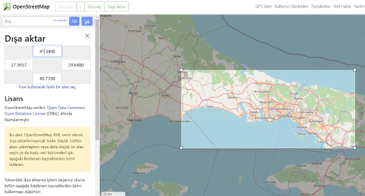
The city I am working on is Istanbul, Turkey. It's a very big metropol city so I started working with one cell of my values. One cell defines an area of 0.66 km². I want to work on 6-7 cells combined (like a smaller part of the city called Üsküdar area.)
This is the whole city which i have the traffic data of all:
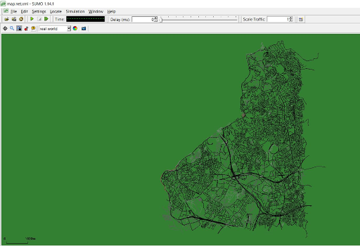
This is the part I am working on (Asian Side-Üsküdar Part):
So in my working area, I create my simulation using netconvert, randomTrips.py, duarouter and create my own sumo.cfg file. Simulation is taking one hour.
What I want to achieve is, create an automation/python code to adjust my simulation according to my real traffic values: for example for Üsküdar, it should be 120 cars, these cars should have max speed of 100, minimum speed is 20 and avg speed is 50. I want to create an automation because I will start with Üsküdar but expand my work later.
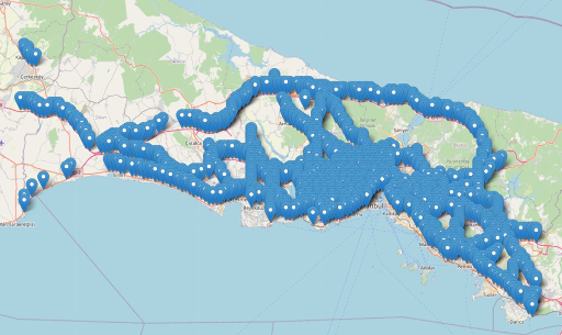
I have created a mapping of my values using python. The below picture defines where i get my values from:
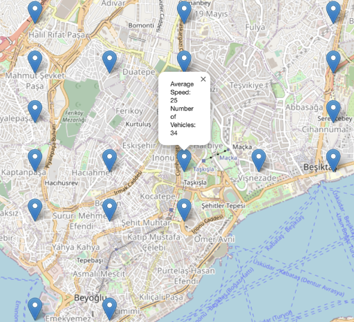
And it shows the values when you tap on them:
I will check it with Traci, but since it's a big simulation I want to take your opinions about if it's possible to start with a small area and automate later on.
Again, thank you very much for your answer.
Best Regards,
Emre AKISKALIOĞLU
PhD Candidate in Mechanical Engineering
Hi Emre,
It is not clear to me whether you intend to build a simulation of a whole city or just of the surroundings of a single/very few detection sites. If you really think of the whole city, you won't get very close to replicate single detector values. Different traffic situations can lead to the same aggregated traffic counts, so even if SUMO can simulate traffic well enough in general, recreating it from local measurements becomes a very hard task.
See https://sumo.dlr.de/docs/Demand/Routes_from_Observation_Points.html for some general overview of how traffic counts can be used in SUMO.
If you want to simulate a small area and pay attention to vehicle dynamics, then you have to calibrate the used car-following model and the vehicle type attributes regarding headway, accel and decel capabilities. SUMO offers the TraCI interface (Python) to read/write data during simulation and use them for own (optimisation) purpose.
Best regards
Mirko
-----Original-Nachricht-----
Betreff: [sumo-user] Building a real-world traffic scenario simulation in SUMO - How to optimize&automate?
Datum: 2023-10-11T11:57:28+0200
Von: "Emre AKISKALIOĞLU via sumo-user" <sumo-user@xxxxxxxxxxx>
An: "sumo-user@xxxxxxxxxxx" <sumo-user@xxxxxxxxxxx>
Dear Eclipse Community,
I have the real traffic data values taken from the municipality in .xml file and it looks like this:
23:00:00</DATE_TIME><LONGITUDE>29.0423583984375</LONGITUDE><LATITUDE>40.9817504882813</LATITUDE><GEOHASH>sxk9hu</GEOHASH><MINIMUM_SPEED>4</MINIMUM_SPEED><MAXIMUM_SPEED>66</MAXIMUM_SPEED><AVERAGE_SPEED>28</AVERAGE_SPEED><NUMBER_OF_VEHICLES>39</NUMBER_OF_VEHICLES></row>
I have millions of cells in in the same format of that .xml file. (File is 350 mb)
Whati did was: I choose one cell and created a map from open street map, then create a random network, route, trips file following SUMO documentation.
What i want to ask is, how can i optimize my simulation according to my values? I want my simulation to have 39 vehicles, and for these vehicles i want the speed values of min. speed 4, max. speed 66, avarage speed 28.
And since i have millions of data, can i optimize it with a python code for each simulation?
I appreciate every help! Thank you so much in advance.
Best Regards
Emre AKISKALIOĞLU
PhD Candidate in Mechanical Engineering